Unmanned Aerial Ecologies: proto-drones, airspace and canaries in the mine
By Honor Harger, April 2013
On Tuesday 16 April 2013, I gave a talk in Brussels at the seminar, Look Up in the Sky!, which was organised by Cimatics as part of their Digital Now programme to coincide with the Brussels Art Fair. Michel van Dartel moderated, Bram Crevits introduced the exhibition he curated for the programme, and James Bridle gave an excellent talk on drones called ‘A Quiet Disposition’, which he’ll be reprising at Lighthouse in Brighton, on 9 May 2013.
My talk followed on from a piece I wrote last November, which looked at contemporary artists’ responses to drones. It was an attempt to provide some recent art-historical context. Below is a rough account of what I said, annotated and illustrated where practical.

C-Astral Bramor UAV during landing, Kilpisjaervi, Lapland, November 2012, courtesy of Marko Peljhan
Tonight, I’m going to talk about the environment that we find drones in. We are going see plenty of drones this evening, in James Bridle’s presentation, so my job is to begin with the natural history piece, and place drones in the wider context of their ecology. So to start, I want to refer to the title of the symposium. Because when you say look up in the air at the sky, I immediately see this:
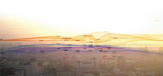
In the Air by Nerea Calvillo and collaborators
Airspace. The space where airwaves propagate. Information space. And that’s the space that I’ve been interrogating my whole career, both as an artist with r a d i o q u a l i a, as a writer, now mainly on the science blog, Particle Decelerator, and as a curator over the past 15 years.
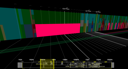
Atlas of Electromagnetic Space by Jose Luis de Vicente & Bestario (2008). Co-commissioned by AV Festival 08, directed by Honor Harger
We often ask ourselves, at events such as the Digital Now, if it still relevant for us to be talking about media art today, when technology has become pervasive, and therefore mundane. Surely, as it becomes enfolded into the practice of all artists, media art as a form becomes obsolete?Well I would argue the opposite, that media artists are some of the culturally deep and urgent guides to a landscape which is becoming increasingly difficult to navigate using the maps and compasses we’ve grown up with. I want to show how media artists are the veritable canaries in the mine, detecting weak signals about how our technolgised world is shaping up, and giving us ways of both perceiving this changing world, and acting within it. In particular, I want to show how media artists have, for the past 15 years, created projects which presciently framed and contextualised the issues and technologies which have collided to enable today’s drone-wars.

Situational Awareness by Marko Peljhan (2007) at Ars Electronica, Austria, 2007
As the oft-quoted science fiction writer William Gibson has said (2007) in relation to new technologies:
'The most interesting applications turn up on a battlefield, or in a gallery.’
That is very much the case, in relation to drones. In many ways, media artists are uniquely qualified to frame a contemporary conversation about drones. Because today to have an interest in drone technologies, whether for military or civilian use, is to have a concern with, and interest in, the networked information space in which they belong. And that is the space that media artists, particularly artists who work from a tactical media perspective, are experts in.
Many of the artists who are making some of the most interesting and impactful work about drones have often found them whilst studying the sky using a whole armory of other instruments. They are concerned with the politics, power structures, architectural infrastructures and mediated activity of the network.

Trevor Paglen with telescope. Photograph from MIT
The network is the drone’s native environment. So, we must – like our colleagues in biology – see them as part of this wider ecology, if we want to better understand their use and their meaning. So, to begin, let’s have a look at the features of this environment.

US predator drone in flight
An Environment of Invisible Infrastructures
The more heavily encoded our world becomes, the harder it is to read. Our technologised world is becoming opaque. Pervasive automated machine surveillance gives us the impression that machines are watching our every move. Algorithms are loose within the stock-market, automatically engineering trades. Entire cities are being planned for the exclusive use of machines. As technology becomes more ubiquitous, our relationship with our devices is becoming ever more seamless, and our technical infrastructure is becoming ever more invisible. We now refer to the vast server-banks which store our personal data as ‘the Cloud’, implying a desolidification of infrastructure that is very much bricks and mortar.
So ingrained has that metaphor become, that a recent survey revealed that over half of all Americans think that bad weather effects cloud computing.

Cloud computing survey commissioned by Citrix, August 2012
The disappearance of our technological landscape from view is a serious political and ethical issue. If we can’t see something, it’s very difficult to comprehend it, let alone to have any political agency in acting on it. This was one of the principle concerns for the Bureau of Inverse Technology[bit] who made this proto-drone 15 years ago.

bitplane by Bureau of Inverse Technology
The Bureau of Inverse Technology was formed in 1991 by Australian engineers and artists Natalie Jeremijenko and Kate Rich. Their work expresses an understanding, and an unease, with the expanding technological capacity of commercial and military organisations.
One of their canonical pieces is bitplane. It was a radio-controlled airplane, equipped with a video camera and transmitter. In 1997, it was launched on a series of sorties over the Silicon Valley in California. Guided by the live video feed from the plane, the pilot on the ground was able to, as the artists put it, 'steer the plane deep into the glittering heartlands of the Information Age'.
It is evident that the artists are expressing a deep concern not only with the militarised component of the military-industrial complex. They are correlating the spaces where the manufacture of weapons and the manufacture of information technology both take place. They are critiquing the economics of the area, the infrastructure of technology, the sites where secret research takes place, the locales where aircraft systems are thought-up and built.
The bitplane flew through what the artists describe as 'rarified information-space'. And they wanted to transgress this space. As the artists themselves have noted, they engaged in several acts of deliberate transgression with this project. Most of the corporate research parks in Silicon Valley were, at the time, no-camera zones and required US Citizen status or special clearance for entry. The bitplane easily sidestepped these regulations. At the time of the flights, it was illegal to fly remotely controlled aircraft within 5 miles of an airport. There were 3 airports within 5 miles of the bitplane flight path. The bitplane also violated FCC communications regulations by transmitting live video on a cable television channel, which somewhat brilliantly, inserted the bitplane's 'gods-eye view' of the Silicon Valley into the regularly-scheduled television viewing of the households below its flight path. Which must have been somewhat unnerving if you’d been watching the aptly named Channel 51.
To paraphrase the artists, the bitplane exposed ‘layers of policing and control over what seemed to be transparent airspace.’ Bureau of Inverse Technology‘s work both reveals the growing capabilities of UAV technologies, but also uses these very capabilities to turn the gaze towards the manufacturers and users of these devices.
This is a classic act of tactical media, a form of activist art practice that goes beyond mere revelation and actively intervenes within a system deemed to be morally, politically or ethically problematic.
This is the central concern of http://www.ladomir.net/bio-summary|Marko Peljhan.

Marko Peljhan, photographed in the Arctic
Strategies of Minimal Resistance
Peljhan is an artist from Slovenia, who’s best known for his post-Utopian work on autonomous living systems, which are inspired by both the conditions of orbital space stations, such as MIR and the ISS, and by the nuclear fall-out shelters which were dotted over Europe for much of the Cold War.

Makrolab, Blair Atholl Estate, Scotland (2002) by Marko Peljhan. Photograph by r a d i o q u a l i a.
Peljhan has always had a deep fascination with the sky, honed by a lifetime of exploring the air through amateur radio, and satellite tracking, but also through physical explorations of airspace, during his time as a pilot. His approach to airspace is summed up here, in a quotation referring to legislation governing the airwaves in Germany:
‘What isn’t forbidden is, of course, allowed. Everything in the air is, in a way, common property.’
Back around the same time as Jeremijenko and Rich were building the bitplane in California, Peljhan and his colleagues were designing this:

TRUST-SYSTEM by Marko Peljhan (1999)
The TRUST-SYSTEM, or Tactical Radio Unified System Transport. The TRUST-SYSTEM was two parallel projects. One was the development of an unmanned aerial vehicle that was intended to act as an extension of the environmental and electromagnetic sensing capabilities of the Makrolab. This eventually evolved into the SPECTRAL-SYSTEM project.
The other project was a plan to transform a cruise missile, for instance a Storm Shadow, into an operational broadcast station, which would deploy radio receivers instead of cluster munitions. The converted missile itself would also be a powerful, and yet stealthy, radio transmitter. Conceptualized as a direct response to the war in Kosovo and the refugee situation there, the TRUST-SYSTEM was designed to be used in conflict, or post-conflict, zones, where broadcast radio and free information, were either technically or politically impossible.
It was first exhibited as an installation at MOMA-PS1 in New York, April 1999. The installation consisted of the plans for the conversion of the missile, as well as actual elements of a cruise missile system. Loaned to the museum for by US and Israeli defense contractors for a technology design exhibition, these components ended being converted into the TRUST-SYSTEM installation.

TRUST-SYSTEM 15 [Tactical Radio Unified System Transport] by Marko Peljhan (1999), at MOMA-PS1 in New York. Image Paula Court
Here Peljhan makes one of the core tenets of his practice explicit. Conversion. He uses this term to refer to the conversion of technologies developed for the military industrial complex into civilian or cultural tools. As he has written (2007):
‘Conversion from abstract to material, military to civilian, from dark to light, from closed to open, from node to network, from old to new and vice versa.’

Territory 1995 by Marko Peljhan (2009), Istanbul Biennale, Turkey
Peljhan was deeply affected by the wars in Croatia and Bosnia. In the project, Territory 1995, first shown at the 2009 Istanbul Biennial, Peljhan grapples with the sense of powerlessness many people felt during the horrific events of the the mid 1990s. In it, Peljhan created analytical maps of the command and control communications of the Serb forces during the Srebrenica genocide in July 1995. It drew on research and field interviews with intelligence sources and survivors in Bosnia and Serbia, and made use of the open source information and documents gathered during the International Criminal Tribunal for the Former Yugoslavia court proceedings. The project maps the military operation that led to the Genocide and explicitly uncovers the electromagnetic and communications traces that were operative during that time.
When war broke out again in Kosovo in 1998-99, Peljhan began to design and build prototypes of systems which were intended to actively contravene military suppression. Seeing that information and communication infrastructure was always vulnerable during times of conflict, Peljhan wanted to create independent infrastructures, which would enable the free flow of communication at times when it was needed the most.

INSULAR technologies by Marko Peljhan (1999-2008)
One of the projects he developed at this time, which remains incredibly influential, to this day, was, //INSULAR Technologies// (International Networking System for Unified Long distance Advanced Radio). This was a prototype to use a network of Shortwave radio transceivers, using automatic link establishment and encryption, to create an alternative, independent internet network infrastructure, able to send and receive basic messages, texts and small files.
‘The system would consist of base HF stations, portable units and gateways to connect it to the global data network. We can gather from military analysis and amateur radio experience over the last 50 years, that HF technology has unique characteristics that make it ideal for long haul communications.’ Peljhan (1999)
TRUST-SYSTEM 22. Images courtesy of Peljhan
But the TRUST-SYSTEM was more radical. It would be mobile, aerial and would utilise the very weapons of war themselves – planes, missiles – to thwart the intentions of the military. The objective was twofold – tactical broadcast in areas cut off by military action, and an attempt to maintain a degree of civilian control. As Peljhan put it in a lecture given at SCCA, Ljubljana, called Strategies of Minimal Resistance (1999):
‘The TRUST-SYSTEM enables the tactical broadcasting of a radio programme over territory where broadcasting by the usual means is impossible because of military actions and civil repression.’
'I, and an entire culture, are interested in how to maintain a degree of civilian control over very aggressive and self-reproducing systems of social repression which use these same methods to keep us under their thumb.’
So here, we see again the core idea of tactical media activism at play. The conversion of tools designed for control or repression, being turned around for civilian, activist purposes. This tactic was at the heart of SYSTEM-77-CCR (SYSTEM-77-Civil Counter Reconnaissance), which showed how UAVs, in the hands of civil society, could monitor the state. It was presented in Vienna in 2004.

Spectral-System (2004). Render courtesy of Nejc Trost
SYSTEM-77-CCR was a tactical urban counter-surveillance system for ground controlled UAVs and airborne drones to monitor public space. UAVs were converted from their role as surveillance-gathering mechanism for governments, to counter-surveillance tools, designed to monitor police aggressive and suppression.
This video created in 2004 outlines the objectives of the project:

Video of System-77-CCR (SYSTEM-77 / CIVIL COUNTER-RECONNAISSANCE) by Marko Peljhan (2004)
There’s an important detail in the above video, which is that Peljhan and his colleagues at Public Netbase in Vienna, tested the legality of their actions right up to the level of the Ministry for the Interior. Police were omnipresent for the duration of the project’s presence in Vienna and were actively gathering information about about the team. After a couple of days, they seemed to relax when they began to understand the project was 'art'. You’ll note in the video, that the then Minister of Interior says that while police are subject to rules, 'art is free'. This was a bizarre legitimization of the SYSTEM-77-CCR endeavor.
This points to a valuable side-effect of contextualising these radical critical actions within the framework of art. Here, stationed in the Makrolab on Campalto Island as part of the the Venice Biennial in 2003, Peljhan underscores this. Here he tells Slovenian television:
Marko Peljhan quoted in Invisible Territory, a documentary by Zemira Alajbegovic, RTV Slovenia, 2007
We may ask ourselves how it is possible for artists to continue to have genuine agency in the skies now, at a time when the drone-wars have escalated to the point that governments are scoring points with one another by intercepting one another’s drones, and broadcasting their feeds live on state television. The above video is a broadcast on Iranian television, celebrating the capture of the RQ-170 drone belonging to the US military in December 2011. Surely now, this space has become too loaded for artistic intervention?
Peljhan’s response to this situation was to team up with his collaborators, Nejc Trost and Samo Stopar (who had worked on SYSTEM-77-CCR), and establish a new company. The intention was to develop prototypes that were created within the context of the art, to a point where they could enter society and start their ‘conversion duties’, on a much wider basis.
{{http://farm8.staticflickr.com/7288/8737373685_5bdf3a6b03_o.jpg}} Nejc Trošt, pictured with C-Astral UAV. Photograph courtesy of: http://is.gd/5VbKJE The resulting company, [[http://c-astral.com/|C-Astral, now design and manufacture autonomous UAV systems. They specialise in creating UAVs which help survey terrain from aerial positions. Their UAVs can operate within a range of scientific contexts, and are used for geographic data gathering, the creation of digital terrain and surface models, and classical surveying.

Bramor gEO UAV from C-Astral, operated by the Kemijarvi Vocational College in Lapland. Photograph courtesy of Marko Peljhan.
The Bramor gEO, their most advanced UAV, has powerful imaging hardware and software, as well as day and night video surveillance equipment, which enables research groups, scientists and indigenous communities, to map their territory, imaging it in ways they would have no capacity to do otherwise. The UAVs are also being considered for use in various conservation and ecological contexts, for example, supporting an anti-rhino poaching campaign in Southern Africa.
So, this is a quite dramatic example of Peljhan’s notion of conversion. Out of a desire to create a series of tactical art prototypes, a successful company specialising on UAVs for civilian, cultural and scientific purposes has been born. And one that ironically, is drawing the attention of the military itself.

Bramor gEO UAV in flight.
All these interventions were made within a wider context of an interest in networked space. We can see in these works that Peljhan has a deep concern with how this is an extension of territory – territory which can be surveilled and controlled. The sky here is not merely a space for flight. It is a space for the transmission and reception of command, control, communications, computation, and intelligence – so-called C4i protocols. Probing this space doesn’t just happen through aircraft. It happens through telescopes, radar, radio, satellites and ground-stations. The drone is simply one mechanism which intervenes into this networked space.
Right now, it’s become one of the most potent technologies, a symbol almost of this networked space, but it would be inaccurate, almost fetishistic, to see the drone as disconnected from the command and control systems which is it intimately connected to. To the physical infrastructure which enables these machines to fly.
Revealing Infrastructures
For the past three years, Lighthouse has been thinking very hard about this. We have undertaken a series of curatorial investigations into these invisible technological infrastructures that make up our world and make it possible for technologies like this to exist.
Invisible Fields
This began in 2011 with the exhibition, Invisible Fields, which revealed the radio spectrum – the invisible environment that enables contemporary technologies of information and communication, including drones. The exhibition was co-curated by Jose Luis de Vicente, and me, and it set out the spectrum as a physical space, invisible but present, a terrain that can be studied, mapped, surveyed and explored.

Immaterials: Light Painting WiFi by Timo Arnall (2011) shown at Invisible Fields, Barcelona 2011-12
It included pieces by practitioners like Timo Arnall, that gave us tangible encounters with the normally invisible technologies which pervade every aspect of our lives, but do so invisibly, and beyond our grasp. That very invisibility carries with it implicit philosophical dangers. As Timo Arnall has recently eloquently written (2013):
‘Intentionally hiding the phenomena and materiality of interfaces, smoothing over the natural edges, seams and transitions that constitute all technical systems, entails a loss of understanding and agency for both designers and users of computing.’
‘Lack of understanding leads to uncertainty and folk-theories that hinder our ability to use technical systems, and clouds the critique of technological developments.’
This applies far more widely than the sphere of design, which is what Arnall was referring to. We can see echos of this in Bureau of Inverse Technology‘s work, and in Peljhan‘s work. This tendency that invisibility has to cloud critique is one of the central concerns of the artist, Trevor Paglen.

They Watch the Moon (2010) by Trevor Paglen. Shown in Geographies of Seeing, co-curated by Honor Harger and Celia Davies at Lighthouse, 2012.
Geographies of Seeing
We exhibited Trevor Paglen’s first UK solo show, Geographies of Seeing, at Lighthouse last year, co-curated by myself and Celia Davies for Brighton Photo Biennial 2012. In it Paglen used the technologies and techniques of astronomical photography to expose the hidden infrastructures of power and the clandestine activities of global government.
His first target was our night sky. The official catalogue of spacecraft in orbit around the Earth has about 20,000 objects in it. What is not in the catalogue is all of the secret satellites operated by the military. Paglen, together with his collaborators, have tracked these secret satellites and photographed approximately 189 of these objects.

KEYHOLE IMPROVED CRYSTAL from Glacier Point (Optical Reconnaissance Satellite; USA 1860) (2008) by Trevor Paglen. Shown in Geographies of Seeing, Lighthouse, 2012
Paglen is interested in how we can use those the tools and techniques of the early Enlightenment, not to reveal unexpected moons orbiting around Jupiter, as Galileo Galilei did, but man-made moons orbiting our own planet, unmapped by any official record. Because if we can not see them, we can't start asking why they are there, what are they doing, what are they looking at, and why all this is being keep from us? These are questions which are fundamentally important to anyone who wishes to have political agency.
Paglen also applies these same techniques to observe and reveal invisible locations closer to home, in particular, secret US military bases. Many of these bases are so remote that there is nowhere that we can go to see them with an unaided eye. They are literally invisible. And this is where Paglen's artistic determination comes in.
Paglen employs high-powered telescopes whose focal lengths range between 1300 mm and 7000 mm. At this level of magnification, hidden aspects of the landscape become apparent. He enables us to get close to facilities we would never normally see. We see surveillance stations that aren’t meant to be there. Airbases which are being used to launch military aircraft, including, of course, drones.
Here we see a reaper drone, getting ready to well, reap.

Reaper Drone, Indian Springs, NV Distance ~ 2 miles (2010) by Trevor Paglen
Paglen did exactly what this symposium exhorts us to do and looked up at the sky. There he found Predator drones, making sorties across landscapes in the US.

Untitled (Predators; Indian Springs, NV) by Trevor Paglen (2010)
And in tandem with in satellite-hacking friends, he then intercepted this:

Drone Vision (2010) by Trevor Paglen
This is a still from Drone Vision (2010), intercepted from an unencrypted satellite channel. Drones are remotely piloted by ground-based operators in the United States who sit in facilities thousands of miles away from the conflict area. The control and video links between aircraft and pilot are often left unencrypted to reduce latency inherent in the system. In this video we see what a drone operator would see, as he pilots his craft towards its target, in Pakistan, Afghanistan, Yemen, or some other undisclosed location.
The Air Itself is One Vast Library
This May, Lighthouse are deepening our examination of invisible infrastructures of the sky by looking at how the technologies of contemporary warfare have the effect of disconnecting us from the ethical implications of military conflict. We’re presenting two projects, one is a major public intervention about drones by James Bridle.

Hercules Missile Landscape by Mariele Neudecker (2010). Being shown at The Air Itself is One Vast Library, an exhibition at Lighthouse for Brighton Festival 2013
The second is an exhibition by the German artist, Mariele Neudecker. Neudecker’s work ordinarily focuses on nature, on the sublime. But following research residency at the historic Nike missile facility in California in 2010, she developed a body of work about aerial weapons of mass destruction. Neudecker’s artistic strategy is rooted in ‘ground truth’, a term used in remote sensing to describe data collected on location. Her extraordinary graphite rubbings of vast Hercules missiles physically capture the object, making what is otherwise abstract and monstrous, tactile and present.

Psychopomp by Mariele Neudecker (2010) – Hercules missile rubbings. Being exhibited at Lighthouse, May 2013
The title of the exhibition – The Air Itself is One Vast Library – is drawn from a quotation from Charles Babbage, the 19th century mathematician and engineer, who originated the concept of a programmable computer. In 1837, in The Ninth Bridgewater Treatise, he wrote:
‘The air itself is one vast library, on whose pages are for ever written all that man has ever said or woman whispered. There, in their mutable but unerring characters, mixed with the earliest, as well as with the latest sighs of mortality, stand for ever recorded, vows unredeemed, promises unfulfilled, perpetuating in the united movements of each particle, the testimony of man’s changeful will.’
By utilising this quotation in her work, and for the title of the exhibition, Neudecker reminds us of the traces that we leave in the world around us. In this instance, she draws our attention to the airwaves and airspaces used by the military. She poetically suggests that despite the machinations of warfare being beyond our daily perception, the air retains a memory of these exploits.
Which calls to mind our last example, a project by the speculative architect, Liam Young, of Tomorrow’s Thoughts Today, who spoke last month at Lighthouse.
Electronic Countermeasures (2011) uses UAVs to create an ad-hoc wireless MESH network for communication. It is a poetic enactment of Babbage’s observation that ‘the air itself is one vast library’ – an information-rich airspace. And, using a completely different type of UAV, it also calls to mind Marko Peljhan’s TRUST System – a conversion of a drone into a communication and broadcast system – in this instance, a mesh network.
Situating a Charismatic Species
So, for Babbage, for Peljhan, for Neudecker, for Young, the air here is a synonym for information space. The sky we’re being asked to look up to is an invisible networked ecology, subject to command, control and communication.

Here be Dragons: the Unstable Landscapes of GPS by Will Gowland (2011)
Drones are just one inhabitant of this informational zoo; one that has become what conservationists would call a ‘charismatic species’. It has become emblematic, canonical almost, of the the anxieties, ambiguities and anticipation that we feel about the environment that begot it. But we would be repeating the classic error of the Victorian natural historian if we attempt to dislocate the drone from its ecology, an ecology of communication networks and economic interests. In order to see what it signifies, we must always see the landscape in which it resides.
Acknowledgements
A very special thank you to Marko Peljhan. Sincere thanks also to Kate Rich, Natalie Jeremijenko, and Usman Haque who helped situate this research. And thank you to all the artists and technologists cited, including Trevor Paglen, Timo Arnall, James Bridle, Mariele Neudecker and Liam Young. Full credits and references at: http://is.gd/uavtalk
This text originally appeared on Honor Harger's blog as 'Unmanned Aerial Ecologies', and is republished here with permission.